Tuesday, 25 September 2012

Welcome

Welcome to the PGDip/MA programme in Landscape Archaeology GIS and Virtual Environments 2012-13.  

My name is Keith Challis and I am a research fellow in remote sensing in the Institute of Archaeology and Antiquity.  I'll be supporting Dr Henry Chapman, the programme leader, by coordinating content and delivery for distance learners in Semester 1 (until the Christmas break) so think of me as your first point of contact and please come to me with questions, problems and inquiries as you have need.  I'll also be teaching a fair part of core content, particularly in the GIS and Virtual Landscapes modules.

You should by now find that your are enrolled on webCT (weblearn.bham.ac.uk) with access to your relevant modules (for continuing students this is module 4: GIS and Spatial Analysis, for new students this is module 1: Landscape Archaeology).  

Teaching begins on Monday 24th September, and webCT content will appear at timetabled intervals from Monday.  In the meantime you should also find that you have access to an induction/administration section on webCT with some information about the course structure, student handbook, etc.

Can I invite you all to read through this material and get back to me with any questions.  I'd also like to invite you to tell us all a little about yourself (continuing students you might want to update the information you gave us last year).  We'll be using a collaborative blog (gianswers.blogspot.com) to discuss and share views and information this year.  You should shortly receive an invitation to register as an author on the blog, once you have done so you will be able to upload and edit content. Use this space frequently to keep us all up to date with your study, learning experience and questions to which others can respond.

Please bear with us over the first few weeks of term as we iron out technical and administrative glitches.  I hope you have an enjoyable learning experience over the next year or two, remember if you have any immediate questions or problems, or as the course progresses, I am just an email or phone call away.


Thursday, 15 March 2012

Surveying with the Global Positioning System

If you are planning on carrying out a GPS-based piece of survey work, Trimble's planning software, mentioned in the lecture this morning, could be helpful.  The software, which is a free download  allows visualization and analysis of the satellite constellation from any given point on the earth's surface, entered as latitude, longitude and elevation.  So it is possible in advance to determine satellite visibility and the optimum time to undertake your work, particularly useful in GPS-marginal areas like some uplands where poor sky view limits satellite visibility.


In a slightly different vein, if you are working with a humble handheld GPS then GPSUtils a free "an easy-to-use application that allows you to manage, manipulate and map your GPS information" is for you.  


Simple download, co-ordinate manipulation and mapping and compatible with a wide variety of handheld GPS; works like a dream with my humble Garmin handhelds.

Saturday, 25 February 2012

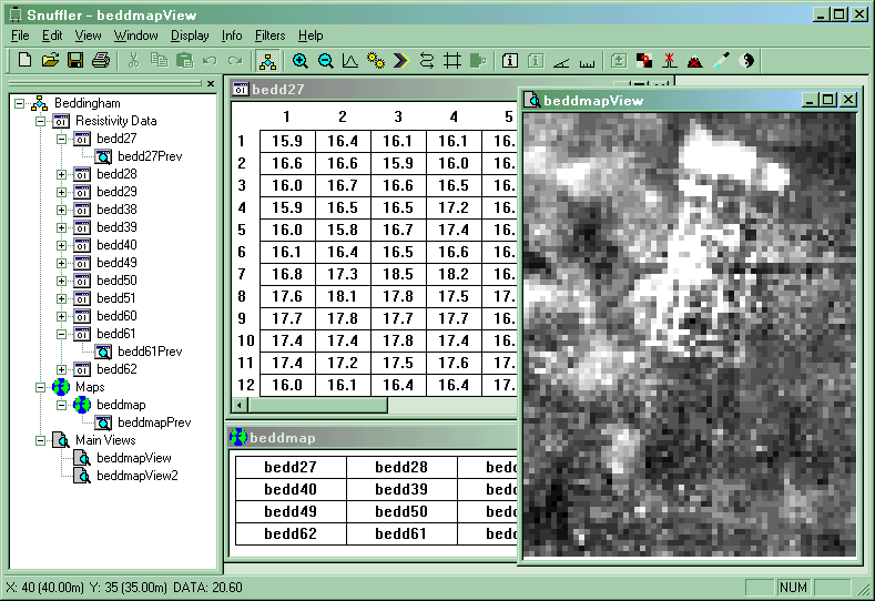
Snuffler, Free Software for Processing Geophysical Survey

If you are working with geophysical survey data from the field school at home, you might care to have a look at Snuffler, a piece of completely free software for processing geophysical survey data.


In the words of its creator, "Snuffler can be used for any set of resistivity or magnetometry data in electronic or paper format, and most importantly it is FREE."


Its Current Features include:
  • Enter data from keyboard or text files
  • Import from RM15 & TR Systems resistivity meters, FM18/36 magnetometers, Arc-Geo logger, Bartington GRAD601 and EPE Resistivity Meter
  • Export of data to text files
  • Previews of data sets
  • Image view in Grey Scale, Dot Density and Relief
  • Display range clipping
  • Data and selection statistics
  • Printing of images with image info
  • Export of images to PNG (Portable Network Graphic) image files and VRML
  • Metadata Storage
  • Continuously sampled data processing
  • Filters, including :
    • Despike
    • Direct modification of data in a selection
    • Interpolation
    • Geological Flattening
    • Sharpen
    • Edge correction
    • Destripe
    • Clip Data
    • Destagger
Download Suffler as a zipped archive from here.

Tuesday, 21 February 2012

Visualizing Geophysical Survey

Two and three dimensional geophysical survey data need good visualization tools.  Golden Software's Surfer and Voxler products are two fine examples. Surfer provides tools for interpolation of continuous surfaces from sample data using a variety of interpolation tools and with a range of outputs from contours to 3D terrain models.


More interestingly, for working with 3D geophysical data such as time-sliced GPR, Voxler provides tools  for 3D interpolation of volumes and modeling and visualization using a variety of methods, including voxels (hence the name) volumetric models, etc.


Save disabled trial versions are free downloads, not time limited and provide an excellent way to get to grips with sophisticated modelling and visualization of geophysical survey data.